
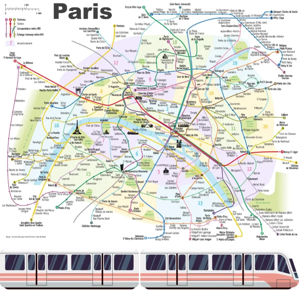
The Paris Métro is one of the world’s most extensive and iconic subway systems, providing convenient transportation throughout the French capital. Operated by the Régie Autonome des Transports Parisiens (RATP), the system comprises 16 lines, serving a total of 308 stations. Each line has its unique route, connecting various districts and landmarks. Here’s an overview of each line to guide you through the City of Light.
Line 1: La Défense – Château de Vincennes
Line 1, the oldest and busiest line, runs from the business district of La Défense in the west to Château de Vincennes in the east. It passes through several key locations, including the Louvre, Champs-Élysées, and Bastille.
Line 2: Porte Dauphine – Nation
Paris Métro Line 2 is one of the sixteen lines of the Paris Métro. Situated almost entirely above the former customs barrier around the capital. Line 2 forms a semi-circle around the northern part of Paris, linking Porte Dauphine to Nation.
It includes notable stations such as Pigalle, Anvers (for Montmartre), and Père Lachaise. It connects Porte Dauphine to Nation and serves 25 stations with a travel time of approximately 35 minutes.
Line 3: Pont de Levallois – Gallieni
Line 3 connects the western suburbs with the eastern part of Paris, linking Pont de Levallois with Gallieni. It passes through popular spots like Opéra and République. Line 3 of the Paris Métro runs from Pont de Levallois–Bécon station in the northwest suburbs to Gallieni in the east.
The line has 25 stations, including Gare Saint-Lazare, and serves many iconic places in Paris, including the Sentier district, the Père Lachaise cemetery, the Bagnolet Park, and the Opera district.
Line 3bis: Gambetta – Porte des Lilas
Line 3bis is a shorter branch off Line 3, running from Gambetta to Porte des Lilas. It provides additional service to the northeastern part of Paris. Line 3bis of the Paris Métro is a 1.3 kilometer (0.81 mile) line that connects Gambetta and Porte des Lilas in the 20th arrondissement of Paris. It is the shortest line in the Paris Métro network and has four stations, including two ghost stations.
Line 4: Porte de Clignancourt – Bagneux-Lucie Aubrac
Line 4 runs from Porte de Clignancourt in the north to Bagneux-Lucie Aubrac in the south. It connects major stations like Gare du Nord, Gare de l’Est, and Châtelet.
Line 4 connects Porte de Clignancourt to Bagneux – Lucie Aubrac. This line has the particularity of allowing connections with all other metro lines. Line 4 metro operates everyday. Regular schedule hours between 00:00 – 23:55.
Line 5: Bobigny-Pablo Picasso – Place d’Italie
Line 5 links the northeastern suburbs to the southern part of Paris, connecting Bobigny-Pablo Picasso with Place d’Italie. Key stations include Gare de l’Est, Gare du Nord, and Bastille.
Line 5 of the Paris Métro runs from Bobigny–Pablo Picasso to Place d’Italie, crossing the east of Paris. It’s the eighth-busiest line on the network and has 22 stations.
Line 6: Charles de Gaulle-Etoile – Nation
Line 6 forms a semi-circle around the southern part of Paris, running from Charles de Gaulle-Etoile to Nation. It is known for its elevated sections, providing views of the Eiffel Tower and Seine River.
The Line 6 of the metro connects the Charles de Gaulle – Étoile station to Nation, which is also the terminus of Line 2, forming a loop within Paris. It was first put into service in 1909, with the initial section Étoile – Trocadéro opening in 1900. It has been operating on its current route since 1942.
Line 7: La Courneuve – Villejuif-Louis Aragon/Mairie d’Ivry
Line 7 is one of the longest lines, with a split route at Maison Blanche, leading to Villejuif-Louis Aragon or Mairie d’Ivry. It connects popular areas like Place d’Italie, Châtelet, and Opéra.
Line 7 of the Paris Métro runs 18.6 km (12 mi) underground from La Courneuve to Villejuif-Louis Aragon and Mairie d’Ivry, with 38 stations in total. The line splits into two branches after Maison Blanche station, with southbound trains terminating at either Villejuif-Louis Aragon or Mairie d’Ivry. Late at night, only through trains operate to Mairie d’Ivry, with a shuttle train to Villejuif originating at Maison Blanche.
Line 7bis: Louis Blanc – Pré-Saint-Gervais
Line 7bis is a shorter branch off Line 7, running from Louis Blanc to Pré-Saint-Gervais. It serves the northeastern part of Paris and is one of the least busy lines.
Geographically accurate path of Paris Métro Line 7bis. 18 January 1911: The section between Louis Blanc and Pré-Saint-Gervais was opened as a branch of Line 7. 3 December 1967 : Because of a lack of traffic, the branch became a separate line known as line 7bis.
Line 8: Balard – Pointe du Lac
Line 8 runs from the southwest to the southeast of Paris, linking Balard with Pointe du Lac. It connects stations like Concorde, Bastille, and Nation.
Line 8 of the Paris Métro connects Balard in the southwest of the city to Pointe du Lac in Créteil in the southeast. The line has 38 stations and is one of the longest lines in the network. The trip between Balard and Pointe du Lac takes about 53 minutes and covers a distance of around 23 km. The line operates every day from 00:05–23:55.
Line 9: Pont de Sèvres – Mairie de Montreuil
Line 9 connects the western and eastern suburbs, running from Pont de Sèvres to Mairie de Montreuil. It passes through popular stations like Trocadéro, République, and Grands Boulevards.
The line links Pont de Sèvres in Boulogne in the west with Mairie de Montreuil in the east via the city center of Paris.
Paris metro line 9 crosses the city from west to east, staying solely within the right bank of the Seine. It leaves from Pont de Sèvres in the southwest in zone 2 and ends at Mairie de Montreuil to the northeast of Paris.
20 kilometers long and stopping at 37 stations, it is one of the longest lines of the Paris metro network as well as one of the busiest.
Line 10: Boulogne – Gare d’Austerlitz
Line 10 is a shorter line that runs from Boulogne in the west to Gare d’Austerlitz in the east. It includes stations like Odéon, Cluny-La Sorbonne, and Jussieu.
Line 10 of the Paris Métro connects Boulogne – Pont de Saint-Cloud in the west of Paris to Gare d’Austerlitz, taking about 40 minutes on average. The line runs under the neighborhoods of the Rive Gauche in the southern half of Paris and the commune of Boulogne-Billancourt.
It crosses the Seine and runs through the Saint-Germain-des-Prés neighborhood, then along the left bank of the Seine.
Line 11: Châtelet – Mairie des Lilas
Line 11 is a relatively short line, running from Châtelet to Mairie des Lilas. It connects central Paris with the northeastern suburbs, passing through stations like Rambuteau and Belleville.
Line 11 connects Châtelet to Mairie des Lilas and the entire route is underground. Connections to lines 1, 4, 7, and 14, as well as RER A, B, and D, can be made at Châtelet. By getting off at Rambuteau, you can visit the Centre Georges Pompidou. République station connects lines 3, 5, 8, and 9.
Line 12: Aubervilliers – Mairie d’Issy
Line 12 runs from Aubervilliers in the north to Mairie d’Issy in the south. It serves key stations like Montmartre, Pigalle, and Concorde.
Line 12 of the Paris Métro runs between Mairie d’Aubervilliers and Mairie d’Issy, and takes about 40 minutes to complete the journey. The line was first put into service in 1910 and named Line 12 in 1930, and was one of the first metro lines to serve the suburbs of Paris. It links Issy-les-Moulineaux, a suburban town southwest of Paris, to Aubervilliers.
Line 13: Saint-Denis/Les Courtilles – Châtillon-Montrouge
Line 13 is one of the busiest lines, with a split route at La Fourche, leading to Saint-Denis or Les Courtilles. It connects major stations like Invalides, Saint-Lazare, and Montparnasse.
Line 13 of the Paris metro runs from Saint-Denis–Université/Les Courtilles to Châtillon–Montrouge, crossing Paris from north to south. The line is 24.3 km (15.1 mi) long and has 32 stations, including Place de Clichy and Saint Lazare. The average distance between stations is 776 m (2,546 ft).
Line 14: Saint-Lazare – Aéroport d’Orly
Line 14 is the newest and the only fully automated line, running from Saint-Lazare to Aéroport d’Orly. It connects major stations like Châtelet, Gare de Lyon, and Bibliothèque François Mitterrand.
Line 14 of the Paris Métro connects the stations of Mairie de Saint-Ouen and Olympiades, passing through the center of Paris and the major stations of Gare Saint-Lazare, The Châtelet–Les-Halles complex, and the Gare de Lyon. The line is fully wheelchair accessible and has nine stations.